
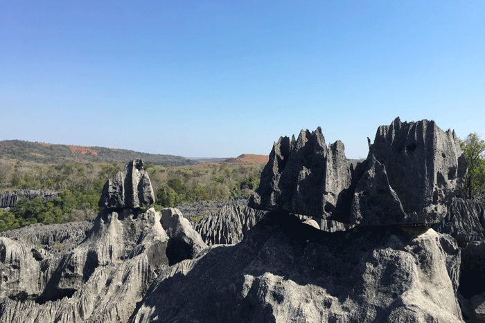
Madagascar’s landscapes don’t just ask to be seen; they demand to be navigated. The Tsingy are the ultimate expression of this truth.
The word *tsingy* comes from the Malagasy “mitsingitsingy,” which means to walk on tiptoes. It’s a fitting description for a place that is less a landscape and more a geological event. These are not merely rocks. They are the eroded remains of a Jurassic seabed, pushed up and then carved by millennia of rainfall into a dense forest of limestone spires.
To the uninitiated, the Tsingy appear as a uniform, impenetrable barrier. But for the traveler who understands the island, they represent three distinct experiences, each demanding a different mindset, a different itinerary, and a different kind of preparation. Knowing which one is right for you is the first step in crafting a journey that goes beyond the surface.
The Grand Labyrinth: Tsingy de Bemaraha
For: The dedicated adventurer with a head for heights.
This is the titan. A UNESCO World Heritage site, the Tsingy de Bemaraha is a vast fortress of stone covering over 1,500 square kilometers in western Madagascar. Getting here is an expedition. The dirt tracks from Morondava are slow, rutted, and require expert drivers in reliable 4WDs. The journey itself is a filter.
Inside the park, the experience is vertical. You are outfitted with a harness and carabiners, not as a theatrical touch, but as a necessity. Your guide, someone we’ve worked with for years, clips you into steel cables as you traverse narrow ledges and cross suspension bridges strung between pinnacles. The sound is of silence, broken only by the wind whistling through the karst and the metallic click of your gear. This is a physical and mental challenge that rewards with a profound sense of isolation and achievement. Wildlife is secondary here; the landscape is the spectacle.
A journey to Bemaraha is never an add-on. It forms the core of a western itinerary, planned months in advance around the dry season, and is often paired with the Baobab Alley and the Kirindy Reserve.
“The track to Bemaraha doesn’t forgive haste. Every kilometer is earned. That’s why the silence at the top of the pinnacles feels so complete.”
The Sunken Forest: Ankarana National Park
For: The wildlife enthusiast and those exploring the North.
If Bemaraha is about ascending, Ankarana is about descending. Located in the north, this park’s tsingy are lower, older, and interwoven with dry deciduous forest. The experience is less about vertical exposure and more about exploring what lies within and beneath the stone. Canyons slice through the massif, leading to sunken forests where families of crowned lemurs leap between the grey limestone and the green canopy.
Ankarana is also a gateway to the island’s subterranean world. The limestone is riddled with one of the largest underground networks in Africa, and with a private guide, you can explore the mouths of some of Madagascar’s unique caves, which serve as sacred tombs and shelters for bats. The trails here are more forgiving, offering circuits that range from a few hours to a full day of exploration.
Unlike Bemaraha, Ankarana is easily accessed from the main Route Nationale 6. It integrates seamlessly into a northern circuit that can include the Amber Mountain, the coast around Diego Suarez, and the archipelago of Nosy Be.
An Ephemeral Sculpture: The Red Tsingy
For: The photographer and the student of geology.
It’s important to know that the Red Tsingy are not tsingy at all. They are not limestone and they are not ancient. This is a landscape of laterite, a soft red soil, carved by extreme erosion into a valley of ephemeral spires. Known as *lavaka*, this is a more recent geological phenomenon.
The visual is powerful, especially in the slanted light of late afternoon. But this is not an expedition. It is a carefully timed photographic stop, a place to witness the forces of erosion in real-time. The structures are fragile, constantly changing with the rains. Access is straightforward, making it a worthwhile detour for those traveling in the Diego Suarez region.
Including the Red Tsingy in an itinerary demonstrates an understanding of the island’s varied geology. It is a quiet, contemplative experience that provides a counterpoint to the scale of Bemaraha or the biodiversity of Ankarana.
Navigating the Stone Forests
Best Season:
Strictly the dry season, from late April to early November. The tracks to Bemaraha are impassable during the wet season, and the park is officially closed. Ankarana is more accessible year-round, but the trails are best when dry.
Physical Level:
Bemaraha requires solid fitness, agility, and a complete absence of vertigo for its Grand Tsingy circuit. Ankarana offers trails suitable for most levels of mobility. The Red Tsingy involves minimal walking.
Duration:
Plan for a minimum of two full days and three nights at Bemaraha to account for the demanding travel. Ankarana can be explored in a full day, but an overnight stay at a nearby lodge allows for a deeper experience. The Red Tsingy is a two-to-three-hour visit.
DESIGN YOUR TRAVERSE
The Tsingy are a conversation between time and stone. We know the terrain, the guides, and the right moment to listen.